


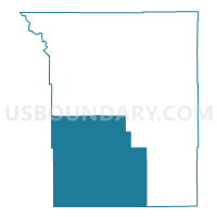
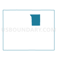
MIDDLE FORK Voting District, Johnson County, Wyoming
About
Outline

Summary
| Unique Area Identifier | 698657 |
| Name | MIDDLE FORK Voting District |
| County | Johnson County |
| State | Wyoming |
| Area (square miles) | 1,146.62 |
| Land Area (square miles) | 1,144.70 |
| Water Area (square miles) | 1.92 |
| % of Land Area | 99.83 |
| % of Water Area | 0.17 |
| Latitude of the Internal Point | 43.70995740 |
| Longtitude of the Internal Point | -106.78256380 |
Maps

Graphs
Select a template below for downloading or customizing gragh for MIDDLE FORK Voting District, Johnson County, Wyoming


Neighbors
Neighoring Voting District (by Name) Neighboring Voting District on the Map
- BILLY CREEK SCHOOL Voting District, Johnson County, WY
- BUFFALO RURAL WEST Voting District, Johnson County, WY
- EDGERTON TOWN HALL Voting District, Natrona County, WY
- KAYCEE Voting District, Johnson County, WY
- LINCH Voting District, Johnson County, WY
- MIDWEST TOWN HALL Voting District, Natrona County, WY
- POWDER RIVER SCHOOL Voting District, Natrona County, WY
- SUSSEX Voting District, Johnson County, WY
- TEN SLEEP Voting District, Washakie County, WY
- UPPER WILLOW CREEK SCHOOL Voting District, Natrona County, WY
Top 10 Neighboring County Subdivision (by Population) Neighboring County Subdivision on the Map
- Hells Half Acre CCD, Natrona County, WY (6,942)
- Casper North CCD, Natrona County, WY (5,620)
- Kaycee CCD, Johnson County, WY (832)
- Ten Sleep CCD, Washakie County, WY (730)
Top 10 Neighboring Place (by Population) Neighboring Place on the Map
Top 10 Neighboring Unified School District (by Population) Neighboring Unified School District on the Map
- Natrona County School District 1, WY (75,450)
- Johnson County School District 1, WY (8,569)
- Washakie County School District 2, WY (732)
Top 10 Neighboring State Legislative District Lower Chamber (by Population) Neighboring State Legislative District Lower Chamber on the Map
- State House District 58, WY (10,860)
- State House District 40, WY (9,987)
- State House District 38, WY (9,702)
- State House District 27, WY (8,533)
Top 10 Neighboring State Legislative District Upper Chamber (by Population) Neighboring State Legislative District Upper Chamber on the Map
- State Senate District 30, WY (20,562)
- State Senate District 22, WY (19,515)
- State Senate District 20, WY (16,427)
Top 10 Neighboring 111th Congressional District (by Population) Neighboring 111th Congressional District on the Map
Top 10 Neighboring Census Tract (by Population) Neighboring Census Tract on the Map
- Census Tract 14.01, Natrona County, WY (5,620)
- Census Tract 18, Natrona County, WY (4,136)
- Census Tract 2, Washakie County, WY (3,326)
- Census Tract 9551, Johnson County, WY (2,475)